
Bottom Line: OsmAnd is a brutal, brilliant, and uncompromising mapping powerhouse that trades mainstream polish for unparalleled offline depth and privacy. It is the definitive choice for anyone who views a smartphone as a tool rather than a tracking device.
To use OsmAnd is to accept a challenge. Most modern software treats the user like a child, hiding complexity behind "smart" defaults. OsmAnd treats you like a professional. The onboarding friction is significant; this is not an app you master in five minutes while sitting at a red light. Instead, it demands an investment of time to configure its dense, widget-heavy interface to your specific needs.
The Interface Paradox
The UI is, frankly, a cluttered mess upon first launch. Buttons and data overlays compete for screen real estate in a way that would make a minimalist designer weep. However, once you push past the initial disorientation, you realize that this clutter is actually unprecedented flexibility. Almost every element on the screen can be toggled, moved, or redefined. You can place a widget for your current altitude next to a button for GPX recording, while keeping a compass and a scale bar in the periphery. It’s a functionalist’s dream, even if it lacks the skeuomorphic charm or slick animations of its Silicon Valley counterparts.
Tactical Navigation
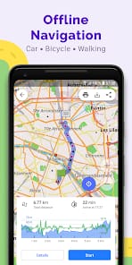
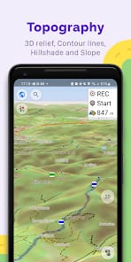
Where OsmAnd truly shines is in its utility loop. Most maps fail the moment you leave the pavement. OsmAnd, however, excels in the "gray zones." During a test through a low-signal canyon, the app’s voice guidance remained crisp and reliable because the logic was executing locally, not waiting for a server to calculate a route. The ability to switch between map styles—topographic for the trail, nautical for the coast, or a standard transport view—is handled with a level of granularity that makes other apps feel like toys.
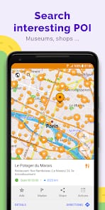
The search functionality, while powerful, is perhaps the most glaring example of the app's steep learning curve. Without a "cloud" to guess what you're typing, you have to be precise. You are searching a local database, which means indexing matters. It lacks the fuzzy-logic forgiveness of Google Maps, but it rewards the knowledgeable user with filtered results (like finding a specific type of craft shop or a hidden spring) that a more "curated" map would bury.
The Privacy Mandate
We must address the elephant in the room: privacy. Most mapping apps are essentially high-precision ankle monitors. OsmAnd is the antidote. Because it functions locally, it doesn't need to phone home. Your movements aren't a data point in some advertiser’s "customer journey." For the security-conscious, this isn't just a feature; it’s the entire point. The app’s commitment to local processing is a refreshing departure from the "connected" requirement that plagues the modern app ecosystem.