

Overview
Most flight trackers open on a map of an entire country and leave the user to find their own house in it. Overflight, from DGR Labs, reverses that hierarchy. It starts from the user’s location and works outward, treating the airspace within view as the whole product. It exists to answer the question that sends most people to a flight-tracking app in the first place: what is that plane, and where is it headed?
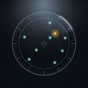
To answer it, the app identifies nearby aircraft and shows the airline, flight number, aircraft type, altitude, speed and track, then tells the user which direction to look. A radar-style scope plots surrounding traffic, and the user can switch focus from one aircraft to another. Range presets labeled Overhead, Near, Normal and Far set how wide the net reaches. The supporting features are well chosen. Military and special-interest traffic and emergency declarations get highlighted. Helicopter and general aviation operators get named instead of left anonymous. Aircraft types link to Wikipedia for anyone who wants background on an unfamiliar airframe.
The data handling reflects a privacy-conscious approach. Overflight needs no account and draws on community-run ADS-B data instead of a proprietary network. The developer says location serves only to find nearby aircraft. The app runs on iPhone and iPad.
The business model is freemium. The free tier keeps one aircraft in focus and times out. Overflight Pro adds live origin-to-destination routes, spoken hands-free callouts, inbound alerts and an always-on display while charging.
The App Store rating is 4.7 out of 5 from 24 ratings, a small sample that settles little. The design’s strengths are the scope interface and accessibility.
Key features
- Nearby aircraft identification: Airline, flight number, aircraft type, altitude, speed and track for traffic around the user, with no national map to wade through.
- Look-here guidance: A directional cue tells the user where to look, turning a data readout into a target in the sky.
- Radar-style scope: Surrounding traffic on a scope that runs north-up or heading-up, with focus switching between aircraft.
- Four range presets: Overhead, Near, Normal and Far, from the jet over the roof out to wider traffic.
- Special-traffic flags: Highlights for military and special-interest aircraft and emergency declarations, plus named helicopter and general aviation operators.
- Wikipedia links: Aircraft types link out for background reading.
- Pro extras: Live origin-to-destination routes, spoken hands-free traffic callouts, inbound alerts and an always-on display mode while charging. The first aircraft’s route and first inbound alert are free.
- Accessibility and privacy: VoiceOver support, no account, and location used only to find nearby aircraft, per the developer.
Analysis
The Local-First Premise
The clearest decision in Overflight is a subtraction. Dropping the country-wide map removes the onboarding friction that makes general-purpose trackers clumsy at their most common job. Someone on a balcony with a jet climbing overhead has no use for transatlantic traffic. They want one answer, fast. Overflight builds its information hierarchy around that moment, and the range presets reinforce it. Overhead, Near, Normal and Far describe what the user perceives. Nobody has to translate a radius in nautical miles.
The cost is scope. Following a relative’s flight across an ocean falls outside the pitch, which concerns the sky around the user. Anyone used to map-first apps arrives expecting to pan and zoom, and a scope centered on their own position asks for a different mental model. We think the trade is right for Overflight’s audience. It does make the app a companion to a full tracker, though, not a replacement.
The Scope and the Compass
The radar scope carries the interface. The north-up versus heading-up toggle matters more than its place in a settings list suggests. North-up is stable and map-like, which suits a device sitting still. Heading-up rotates with the device, so the aircraft at the top of the scope is the one in front of the user. That is the right mode for holding a phone toward the sky. Offering both covers the app’s two postures: active spotting and passive monitoring.
The “which direction to look” guidance turns telemetry into something physical. It is also the design’s weakest point. It depends on the device’s compass, and the obvious worry is drift near buildings or inside cars could send users squinting at empty sky. That is a design-level risk, not a documented defect. Even so, steel and electronics easily disturb magnetometers, so the app’s most compelling feature rests on a fragile sensor. Haptic feedback would help: a pulse as the phone swings onto the target would let the user keep their eyes on the sky, which is the point of looking up.
Focus switching keeps the scope readable. One aircraft gets the detail while the rest stay as context. That is a sensible hierarchy for a phone screen, where several equal-weight data blocks would collide.
Data, Coverage and Trust
Community-run ADS-B data is a principled source with predictable limits. It spares users an account and fits the hobbyist culture of plane spotting. It also means coverage depends on volunteer receivers near the user. Dense areas around major airports should fare well, sparse regions may not, and aircraft that don’t broadcast ADS-B won’t appear. None of this is DGR Labs’ fault, but the local focus makes gaps more visible. A national map hides a thin patch. A scope centered on the user’s backyard puts it in plain view.
The special-traffic layer is where the data pays off. Military and special-interest aircraft and emergency declarations are the flights that make people stop and stare. Flagging them gives Overflight its most shareable moments. Naming helicopter and general aviation operators matters for a similar reason. The low, loud traffic over a neighborhood is often a helicopter or light aircraft, and an operator’s name tells a layperson far more than a registration code. The Wikipedia links are a cheap, effective finishing touch. Overflight doesn’t need to build an encyclopedia when it can point to one.
Accessibility by Design
VoiceOver support and spoken callouts make Overflight useful to people who cannot see the aircraft it identifies. The callouts also help sighted users: announcing traffic hands-free lets the phone stay in a pocket on a walk.
That makes the callouts’ placement awkward. VoiceOver support isn’t listed as a Pro feature. The callouts are, and they are the feature that most directly turns the sky into audio. The accessibility story is only complete for paying users.
The Free/Pro Split
The free tier is substantial. It includes detailed flight data, both radar orientations, all four range presets, the special-traffic flags, operator names and Wikipedia links. It also keeps one aircraft in focus and times out, unlike Pro.
The paywall’s weak point is routes. Overflight’s founding question has two halves: what is that plane, and where is it going? Live origin-to-destination routes answer the second. Giving away the first aircraft’s route is a smart sample, but after that the free tier answers only half the question. The split invites reservation: routes feel like core functionality. Callouts, inbound alerts and always-on mode feel like the natural premium.
The subscription structure asks users to decide how committed they are. Monthly access suits a short burst of interest, annual access suits regular use, and lifetime access is a long-term bet that DGR Labs keeps maintaining the app.
Visuals & performance
The radar scope is skeuomorphism with a reason. A polar display is the natural way to show bearing and distance from a single point, which is exactly the relationship between a spotter and the traffic around them. Air traffic control uses the same geometry for the same reason. The radar-style interface is polished. The visual language also tells newcomers at a glance that the app is about what surrounds them, not a map to explore.
The open question is density. A focused aircraft with its full data block, a directional cue and a busy scope is a lot for a phone screen. The single-focus model is the right answer. Haptics would move some of that load from the eyes to the hand.
Performance can only be judged as a design expectation. A 2D scope and text readouts are light work for any device running a recent iOS version. The heavier cost is continuous location, compass and network activity, which presumably explains why the always-on display mode requires charging. How fresh and complete the data is depends on the community ADS-B feed, not on the app.
Platform nuances
Overflight covers iPhone and iPad, and each brings a different part of the design forward.
- iPhone: The natural home. The compass, heading-up radar and look-here guidance all assume a handheld device pointed at the sky. Spoken callouts suit a phone in a pocket, and the always-on mode suits a phone on a desk or nightstand charger.
- iPad: A larger canvas for the scope and data panel. Holding a tablet up to the sky is clumsy, so north-up monitoring fits it better than active pointing. The always-on mode while charging turns a docked iPad into a traffic display.
Across both, the app supports VoiceOver and needs no account.
Final verdict
Overflight does one thing that general-purpose trackers handle poorly: it turns the plane overhead into a labeled target the user can find in the sky. The local-first scope, perceptual range presets, special-traffic flags and operator names all serve that job. VoiceOver support and spoken callouts extend it to people who cannot see the aircraft at all.
The weaknesses are structural and easy to name. Pointing guidance inherits the compass’s sensitivity to interference. Community ADS-B coverage varies by location. And the Pro tier claims routes, the feature that completes the app’s central question.
Pro is fairly priced for anyone who looks up often, but the free tier is a capable identifier that leaves users wanting the rest. We recommend Overflight to spotters, households under a flight path and blind aviation fans, alongside a map-first tracker for everything beyond the visible sky.
Reviewed by the Rankeno Productivity Desk. Scores are out of 10; the overall score is the desk’s editorial judgement, informed by the four sub-scores above. How we review